The Embassy Cinema Site - Beeston - a pictorial record
The Embassy Cinema was planned to be built in Beeston Square and a start was made in 1939, before building was abandoned at the
beginning of World War 2 in September of that year.
As little evidence of the building itself survives in pictures, this page records the history of the site as well
as the scant evidence that was recorded.
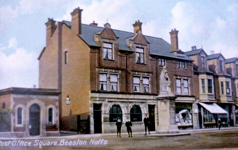
The frontage of the Embassy cinema was to be built on the north side of Beeston Square on the site of what had been the Post Office before that latter
was replaced by a new Post Office (now The Last Post pub) in about 1938. The old Post Office was built originally about 1900 and was then a small structure (shown here in about 1905). On its
right is a gate and driveway leading to Round Hill House, the home of the Foster family.
To its right is what was then London City & Midland Bank, next is a draper's shop,
then Commercial Buildings. In the foreground stands the Boer War memorial (now in Broadgate park)
The driveway still exists as a pedestrian access to Foster Avenue carpark;
the bank building still exists, much modified, as HSBC. Commercial Buildings remain, more or less unmodified.
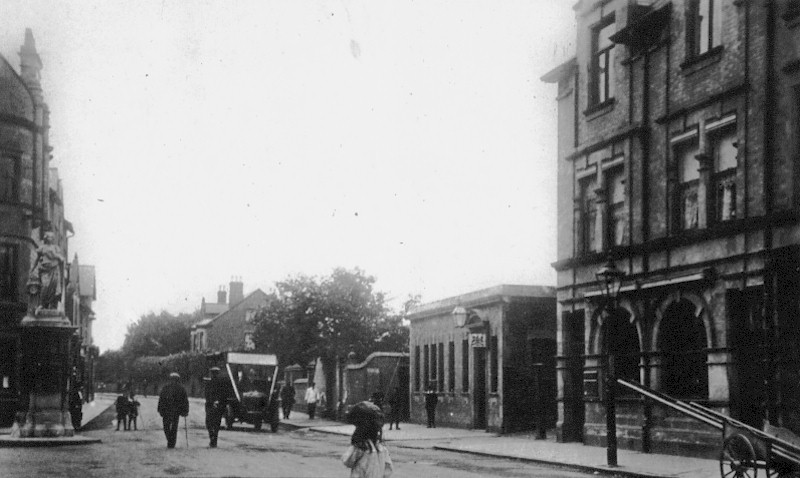
This view shows the site, now with an enlarged and remodelled Post Office in about 1910 with the entrance to the Foster house and the bank clearly seen.
In the background
can be seen Oban House (later the home of Dr Thompson, now Social Services offices).
A very early Bartons bus is approaching along Chilwell Road. Behind the memorial
is the old Town Hall.
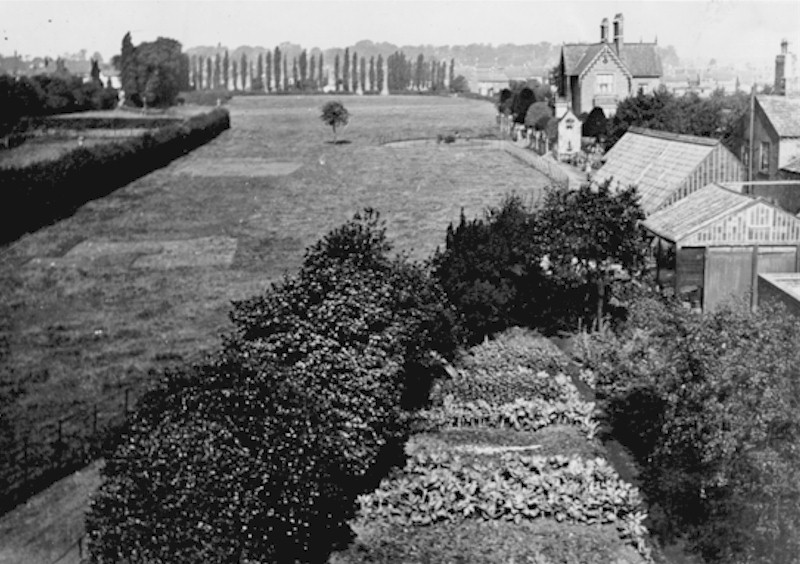
In August 1935, Hannah Maria Foster died. She was the last of the Foster family to live in Roundhill House and, as a result, her property was put up for sale.
This
photograph, of the land to the rear of the old Post Office, shows the remarkable extent of the land, which still existed in central Beeston at that date.
On the
left, a hedgerow runs along the ancient path to Bramcote, which was soon to become Foster Avenue. This can be seen in the distance running at an angle towards the line
of Bramcote Road.
This was later diverted when Roundhill School was built but still exists as a pathway around the school site. In the distance, beyond the small tree is
now the site of Roundhill School.
The house on the left, with the turning circle and ornamental features, was the Round Hill House, the Foster home.
The
greenhouses were presumably originally associated with the Foster (later Foster & Pearson) horticultural building business.
The vegetable garden in the foreground was
probably associated with living accommodation to the old Post Office. This part of the land, extending to the path on its right, became the site for the Embassy.
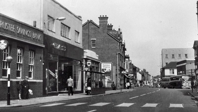
After building was abandoned, the frontage to the Square became a poster site. This continued until the early 1960s when Barclays Bank was extended and the Derbyshire Building
Society building were built there.
This photograph shows the site, in the early 1960s, just before the poster site was developed. Part of the posters ('Golden Virginia') can be
seen, as well as what may be a 'For Sale' sign.
To the the left of the site, are the original Barclays Bank, Gas Showrooms and TSB Bank, all of which had been built in the late
1930s after the release of the Foster land.
The Midland Bank can be seen, still in its original form. Opposite, are Bartons buses calling at the bus stop in The
Square, with Boots, Doars shop (by then acquired for redevelopment and occupied
temporarily by Trevor Nelson's furniture shop) and National Provincial Bank, then on the corner of
Station Road. Beyond that can be seen Victor Oade's mensware shop and the old silk mill.
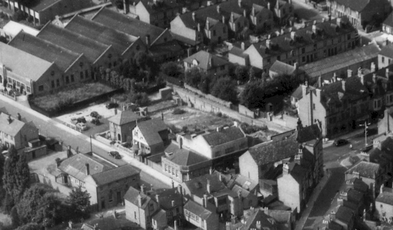
The foundations of the Embassy survived for several years after the War and can be seen, with the poster site on the frontage to The Square, on the aerial view of the area.
Position
your mouse on the image to highlight the position of the abandoned building site.
Anyone who has difficulty understanding the locality of this scene, may
click here to view mapped image of the wider central area.
The site was improved and gradually consolidated with adjacent lands to become a carpark.
Ultimately, this
included the site of 2 & 4 Foster Avenue and parts of Barlows hosiery factory where the Civic Offices were also built.
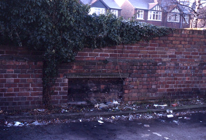
In the 1980s, this remnant of the foundations of the cinema
could be seen, built into a wall at the rear of number 4 Foster Avenue before it was demolished and incorporated into the carpark.
Nothing of the foundations is now visible, having
been buried under the carpark and the Embassy cinema is largely forgotten.
The photographs are from David Hallam's collection.
© David Hallam - 2010
Close this window to continue
|  |