| Home Topics Memorials Miscellany Transcripts References Family History Glossary Latest Beeston Blog About us | Site Search |
|
The Origins of the Placenames and Fieldnames of Beeston (E to M) - by Ivan MorrellEast or Tuttle Bridge Field - One of the three open fields of Anglo-Saxon and Medieval Beeston, East Field lay to the north of Beeston and to the east of Cowgate[Wollaton Road]. Its alternative name, of Tuttle Bridge Field, originated from the bridge over the Tottle Brook, which was located just to the west of the present Priory Island on Derby Road. The name Tuttle Bridge Field must be prior to the 1612 enclosure and the creation of the Far Field because, after 1612, the bridge was situated in the newly established Far Field. The names derive from O.E. Ēast, Toot, Hyll, and Brycg and Feld. Le Esthalle - This early 14th Century name is derived from O.E. Ēast and Halh, meaning the eastern nook or corner of land. The only nook we know about that fits the location is Old Comb Nook, but it could easily have referred to other locations, the names of which are now lost and unknown to us. Far Field - Far Field appears to have been created after the enclosure of Nether Field in 1612. It was carved out of the northernmost sections of Church Field and East Field. Far Field stretched from the Beeston Fields ridgeline across the Derby Road to the Beeston / Wollaton parish boundary. The field has also been known at various times as Darbygate Field as well as Steppa or Steopoe Field, the name which is self-explanatory derives from O.E. Feorr and Feld. Far Hill - Was situated, as its name implies, in the furthest part of the parish, in the Far Field at the top and to the east of Sandy Lane on the Beeston/Bramcote/Wollaton parish boundary. This same plot was known in the mid 19th Century as the West Upper Field. The name derives from O.E. Feorr and Hyll. Field Close - This was the northernmost of the Brook Closes in the Tuttle Bridge Field, located in the area of the present Meriden Avenue. Field Close is mentioned on the 1817 plan of the Lenton and Beeston estates belonging to James Green. The name derives from O.E. Feld. The Flats - The Flats Closes including Long Flat, Middle Flat, Nether Flat, Over Flat and Smauley's Flat were all part of the Nether Field, the name deriving from O.Scand Flatr. They encompassed all of Beeston Rylands west of Meadow Road and to the north of the present Jolly Anglers Inn, including the eastern half of the present Siemens site.The name could have derived from the term "Flatted" meaning the portions into which a common field was divided possibly involving the removal of any of the common fields baulks or hedges . Alternatively the name may refer to a low lying level tract of land. The land from the railway to the Jolly Anglers is level compared with the areas to the north and south, to the north the land begins to rise slowly and to the south the land falls away slightly. The name Smauley derives from the family of William Smalley a yeoman mentioned in a 1608 deed. Flitter Lane and Flitter Croft - Flitter Lane led from Nether Street to the Pasture Dyke in the area of the eastern end of the Nether Street School, Flitter Croft was situated near to the present northern end of King Street. Flitter is thought to derive from O.E. Fleot meaning a rivulet or stream, referring to the Pasture Dyke. Foal/Fole/Foale Close - This close, mentioned in 18th Century deeds, must have been located in the Nether Field somewhere near to the Trent Close, Barn Close and Rushy Close that were also mentioned in the same deeds. The name derives from O.E. Fola, the close where young horses were kept. Fold Lands - This name, from an 1863 Middleton Estate Map, appears to be a post-enclosure name for the Toadlands, see below. The name is believed to have originated from O.E. Fald, meaning an animal enclosure. Frog Hall - Was located in The City, the easternmost part of the old village of Beeston, and is thought to represent the site of one of the three Anglo-Saxon manors of Beeston. It is not known why it was so called, but one imagines that this was a damp and mirey place, where frogs could breed readily. This end of Beeston was noted for the flooding of the Pasture Dyke here until fairly recent times. The name derives from O.E. Frogga and Heall. Garbroad - Situated in the Tuttle Bridge Field, in the area where the present Marlborough Road meets Abbey Road and Hetley Road. The furlong was named from its triangular shape deriving from O.E. Gāra, with the second syllable deriving from O.E. Brād which referred to the width of the strips. Gleadwong - This was the area of the old Nottingham R.F.C. pitches and the adjacent sports field off Ireland Avenue. The ditch alongside the old entrance to the Rugby Ground was the Gleadwong Drain.The name derives from either O.N. Gleða or O.E. Glida both meaning a kite or O.E. Glæd meaning a glade, and O.Scand.Vangr meaning a meadow. The short section of Dovecote Lane from Queens Road to Ireland Avenue is shown on the 1809 Enclosure Map as Gleadwong Road. The Goares - The name is known from 1687 and 1718 documents, which state that was situated in the Church Field. The name, which derives from O.E. Gāra meaning the triangular shaped land, could have been an earlier name for Pye Close. Goss Close - This is a post-enclosure name from the 1863 Middleton Estate Map for the northernmost section of Cowgate in the Tuttle Bridge Field, in the area of the present western half of Clifford Avenue. The name derives from O.E. Gōs, meaning the enclosure where geese were kept, The Grange and Tithe Barn - The Grange or Church farm of Lenton Priory is believed to have stood on the site of a building known as The Grange which is now the Police Headquarters on Chilwell Road. The Tithe Barn was situated on the eastern side of the churchyard, near to the present Wilkinson's store .When Lenton Priory appropriated the church at Beeston around 1160, it would have come into possession of Beeston's Great Tithes. Tithe which derives from O.E. Teoða meaning a tenth, was a payment of a tenth of yearly cultivation and stockrearing, to support the parish church and its clergy. It is usual to refer to tithes as Great or Small Tithes. Great Tithes, which were also known as Rectorial Tithes amounted to two thirds of the total tithe, were paid to the mother church, usually a Minster, Abbey or Priory, until the time of Henry 8th and his Dissolution of the Monasteries, when many fell into the hands of laymen. These great tithes originally comprised the products of crop husbandry or things that grew and increased annually, such as grain, hay, wood and vegetables. As the mother church was often remote from the parish it was normal for it to have its own Grange or Church Farm on site. It normally provided the local vicar with the Small Tithes, also known as Vicarial Tithes, for the support of the vicar and his parish church. Small Tithes amounted to one third of the total, comprising the products of animal husbandry such as calves, lambs, wool, milk and eggs, and the products of man's labours such as milling and fishing. Since early times money payments had begun to substitute these payments of crop and animal husbandry. In 1836 an Act commuted these payments to a tithe rent charge, before they were finally abolished in 1936. Gravel Pit - There were several known Gravel Pits in Beeston, the Tottle Brook Pit in the Brook Furlong opposite Salthouse Lane, the Stoney Street Pit, the Roundhill Pit near Broughton Street, Foster Avenue Pit and probably many others. The name derives from O.F. Gravele and O.E. Pytt. Gravel Pit Closes and Gravel Pit Hill - Were in the general area of Abbey Road, Albion Street, Stoney Street, and the grounds of Roundhill School. Gravel Pit Lane - Gravel Pit Lane was the southernmost section of Cowgate Road[Wollaton Road], from the present Square to Cross Street, this same section has also been known as Butchers Lane. Greengate - The name Greengate connecting Meadow Road with Brown Lane is suggested from the name Greengate Close on the 1809 Enclosure Map and Award, and from a 1611/12 Terrier which mentions a strip of land on the Longlands near to the present Lavender Grove, which had Greengate Hedge as its western boundary. Greengate then may have been an earlier name for the southern half of the present Station Road and its junction with Meadow Road. The name normally derives from O.E.Grene and O.Scand.Gata, meaning a grassed trackway or occupational lane that gave access to the open fields. Gullet Bridge - Gullet Bridge, according to a 1786 document, was situated in the Upper Meadow. It possibly provided access over Blotah Dike for the old footway now represented by Trent Road.The name derives from F.Goulet and O.E. Brycg referring to the gulley or waterchannel of Blotah Dike. Le Halacheris - This name from a 14th century document, meaning The Hall Acres is identifiable with the Hallcroft group of names below. It is derived from O.E. Heall and Æcer. Halfacres - Land that was divided into half acre plots or strips. See Holehalfacrehendes below. Hallcroft - Thought to be the site of another of Beeston's Anglo-Saxon halls or manors on the western side of the village, hence the name which derives from O.E. Heall and Croft. Hallwong, Hall Croft Close, Open Hall Croft, Hall Haverlands and Hall Pitts were all in the same general area at the western end of Beeston, to the north and south of the present Chilwell Road. Hanging Meer - Refers to a footway / boundary, situated in the Far Field, that led from Derby Road opposite Wollaton Road, to Wollaton. The name derives from O.E. Hangian, referring to the sloping ground here, and from O.E. Gemære which refers to the boundary. Hassocks Lane - The first section of this lane still exists, but originally it would have continued its course across the modern Highfields sports pitches and Tennis Centre to the deserted medieval village of Morton now marked by the junction of Beeston Canal, the railway line and the flyover at Dunkirk. Along Hassocks Lane stood Hassocks farm, the site now marked by one of the changing rooms for Highfields sports pitches. All of the playing fields on the southern side of University Boulevard were once part of Beeston and were known as the Hassock Closes. The Hassocks, which derive from O.E. Hassuc meaning a tufted coarse grass were originally moorland or marshy ground - hence the name Morton of the deserted village. One of the closes was mentioned in the 1589 will of John Dale Haverlands - The Haverlands were situated in the Nether Field, in the area of the present Dovecote Lane Recreation Ground and Georgina Road. The name derives from O.Scand. Hafri and O.E. Land, meaning the land/strips where oats were grown. Heanings and Heaning Dyke - The Heanings were on the northern side of the present Dovecote Lane Recreation Ground in the area of Leslie Avenue. Heaning Dyke ran from West End and just to the north of Leslie Avenue, to Dovecote Lane. Known as Le Heynynges in the 14th Century, the name derives from O.Scand. Haining meaning a piece of meadow. Heaye Heads Furlong - Situated in the Tuttle Bridge Field, probably near to the Common Balk on Broadgate. The name, which was listed on the 1601 Terrier, probably derived from the family of Robert Hey and O.E. Heafod and Furlang. High Road - Known on the 1809 Enclosure Map as Turnpike Road, the Nottingham to Sawley toll road. The word turnpike which dates from about 1420 originally referred to a spiked barrier which could be turned about a pivot, to either restrict or allow access to people on horseback. Turnpike's later meaning dating from the 17th Century, refers to roads where a toll was exacted to pay for the upkeep of the road. The modern name meaning the uppermost of Beeston's main thoroughfares derives from O.E.Heah and Rād. Hipton Meer and Hypton Willows - Hipton Meer, which marked the site of one of the boundaries in the Church Field, was situated in the area of Elm Avenue. The actual Meer or boundary was the Church Field Drain, down which Willows would have grown, giving rise to the Meer's alternative name of Hypton Willows. The name Hipton/Hypton would denote the owner, while Meer and Willow derives from O.E. Gemære and Welig. Holehalfacrehendes - This name, and the possibly associated name of Halfacres were both mentioned on the same 1337 document. From the itinerary on the document they would have been located somewhere close to, or within, the old village confines. The "Hole" element refers to early gravel workings or to a natural hollow, while "hende" refers to a corner or somewhere close at hand where the land would have been divided into half acre strips or plots. The name derives from O.E. Holh, Healf, Æcer and Hende. Holgate - Documented as early as the 14th Century, Holgate is thought to be possibly an early name for Dovecote Lane. The name derives from O.E. Holh and O.Scand Gata, meaning the hollow road, its surface worn lower through years of constant use. Holt - Mentioned on the 1809 Enclosure Award, this small wood or thicket was located on the northern side of Queens Road, near to its junction with Hassocks Lane. It as been noticed that the Holt placenames normally occurred adjacent to trackways that crossed marsh or moorland, as the lane did in this case. The wood from the holt is thought to have provided brushwood to line and stabilise the trackway in periods of wet weather. The holt may have also provided willow canes for basket making. The name derives from O.E. Holt. Home Corner Closes - This group of closes were situated on the eastern side of Boots Bridge, both on the present Boots site and on the western end of the ex-railway sidings up to the Beeston/Lenton parish boundary. Their name implies they were moorland that formed a corner where they joined up with the Hassock closes, and derived from either O.E. Holm or O.Scand. Holmr and O.F. Corniere. Hoppet or Hopper Close - This was one of the Musco-Sike group of closes, now marked by the southwestern end of the Boots site. The name Hoppet is Old English for a small enclosure. Horse Doles Closes - The Horse Doles were that part of the old University playing fields, from the end of the track on the southern side of Beeston canal, up to the rear entrance to the Boots site on Thane Road. It has been thought that the Horsedoles may have been the 24 acres of Meadow that were were recorded for Beeston in the Domesday Book. The Horse Doles originally the part where horses were pastured, the dole being the share of the total number allowed for each farmer. They were enclosed as early as 1325 to enable more sheep to be grazed. Though shown as within Beeston on the 1809 enclosure map, they are now part of Lenton parish. The name derives from O.E. Hors and Dāl. Hoe Land / Howland and Hoe Land / Howland Cutts - Situated in the Tuttle Bridge Field in the area of the present Boundary Road and its junction with Hetley Road. The form Hoe Land on the 1601 Terrier derived from O.E. Hoh and Land, means strips of cultivated land on a hill-spur. The name Hoe Land Cutts denotes that this land was cut out of the Hoe Land Furlong. The form Howland is a later corruption of Hoe Land. Intake Close - Documented in the 1818 will of Thos. Charlton along with the Heanings and Robinett Close, the name here which may be a general term rather than specific name derives from M.E. Intak meaning land taken in from moorland. As such, it frequently occurs on old village maps. For Beeston, the name also occurs on an 1834 Indenture, which mentions that Intake was the name for the land formerly known as Toadlands Close in the Far Field. Landfurlong - Documented in 1333, if this is the correct name it could have been anywhere within the parish. It may however be a mis-spelling or corruption of the Langforlangs below, as William de Amyas of Nottingham is mentioned on this 1333 document as well as on the two 1337 and 1341 Langforlang documents. Leys Close - This small close of the Tuttle Bridge Field, which appears to have been enclosed early, was situated on the northern side of the High Road in the general area of its present junction with Marlborough Road. Leys Close is almost certainly the one Little Close mentioned on the 1601 Terrier. The name which derives from O.E. Lēah had originally meant a woodland clearing, but later its meaning changed to just a meadow, which would have been its meaning here. Great and Little Longdens - The name, which is known from 18th Century documents of the Drury family, relates to the Longden family of Nottingham and Bramcote who held land in Beeston. On the 1809 Enclosure Map, John Longden is shown holding the previously named Derbygate Hurst, the Toadlands and Far Hill situated on the eastern side of Sandy Lane which were by then one single field. The Great and Little Longdens totalling 12 acres would have been part of this land, which totalled 28 acres. The Longdens married into the Sherwin family and after John Longden died in 1818 his offspring and heirs, who were up to that time named Sherwin Longden, just went by the name of Sherwin. Longfurlong / Langforlangs / Langforlanghend - These names, mentioned in documents dated 1337 and 1341, are probably early names for the Long Roods in the Tuttle Bridge Field, deriving from O.E. Lang and Furlang. The hend element of Langforlanghend would have referred to that part of the then furlong nearest or closest at hand to the village. Mickle and Muckle Dole, Mucklekirk Leys - These fieldnames, from an 18th Century document, were situated in the Common Meadow between the Beeston Canal and the Trent. Both Mickle and Muckle have the same meaning of large, with Muckle normally denoting the slightly larger of the two. Mucklekirk Leys would have been part of one of the five large meadows in the Common Meadow listed under the vicar's holdings on the 1809 Enclosure Map. The names derive from O.E. Micel, M.E. Muckle, O.E. Dāl, O.Scand Kirkja, and O.E. Lēah. Long Hill - This close, whose name is self-explanatory and derives from O.E. Lang and Hyll, was situated in the Far Field, in the area of the present Heather Cresent to the north of Derby Road. On the 1863 Middleton Estate Map, the northwestern quarter of Long Hill was known as Sand Flat, a name referring to the sandy structure of the soil. Nurseries are recorded here during the late 19th and early 20th century, the sandy soils being put to good use in horticulture and market gardening. Longlands Drain and Closes - Longlands Drain ran from Meadow Road to Musco Sike Road from somewhere in the region of Lavender Grove, to the cul-de-sac end of Leyton Crescent. The Longlands Closes were the lands to the south of Longlands Drain bounded by Meadow Road on the west, the old Longlands Road on the south, and Musco-Sike Drain on the east. The name derives from O.E. Lang and Land, meaning the long cultivated strips.
Long Roods - As it name implies, this close was a long narrow field. It was situated in the Tuttlebridge Field in the general area of the present southern central section of Clifford Avenue, and Abbey Drive and Firs Avenue. The name derives from O.E. Lang and Rōd. Lynpol - This name, mentioned in a 1316 document, can only relate to part of the later Blotah Dyke the course of which Beeston canal now follows. The document deals with land in the West Meadow, known later as the Upper Meadow, between the Lynpol and the Trent that was leased by Richard Wyluby. So it appears that Blotah Dyke was at one time also called the Leen. It is known that the Normans diverted the course of the Leen to serve Nottingham Castle, so it is possible that Blotah Dyke and the present Beeston Canal may signify a division of one of the Leen's original courses. Lynpol derives from the root word lei which means to flow and O.E. Pōl. Maltlands and Maltland Meer - The close called the Maltlands was situated in the Tuttle Bridge Field in the area of the present northernmost half of Manton Cresent. Maltland Meer, which formed the northern boundary of the Maltlands, appears to be an continuation of the Common Baulk. The names derive from O.E. Mealt and Land meaning land where they grew such crops as Barley with O.E. Gemære referring to the boundary. Martin's Croft - This small enclosure, which was probably named after the family of Luke Martin who witnessed a Beeston land conveyance in 1698, occupied the area now covered by Barrydale Avenue. The same name also occurred at the western end of Chilwell village. Market Street - Market Street was the western end of the present Middle Street, between Dovecote Lane and Brown Lane [Station Road]. The name originated from a corn market that would have been held at the old cross at the top of Dovecote Lane in medieval times and derives from L. Mercatus and O.E. Stræt. Meadow Road - In 1809, Meadow Road commenced at Leslie Avenue running down what is now Dovecote Lane to Queens Road, then along the short sections of Queens Road and Station Road about as far as the modern railway tracks. From here the road became known as Flats Lane, before continuing once again as Meadow Road from the area of the present Longlands Road down to the canal. Once over the canalbridge, Meadow Road turned east running alongside the canal to the Horse Doles Close [now in Lenton], from here a track continued running diagonally across the Horse Doles into Lenton Parish, to the ford crossing the Trent at Trentside Farm. As its name implies, Meadow Road was the main road out of Beeston to the meadows and pastures in the south of the parish, deriving from O.E Mædwe and Rād. Nether and Over Meergate - These two closes were situated in the Tuttle Bridge Field, in the general area of the present Warwick Avenue and the central area of Marlborough Road. The name Meergate documented in 1333 as Meregate, signifies that the boundary known as the Common Baulk may once have been used as a road or trackway. The names derive from O.E. Niðera, Ofer, Gemære, and O.Scand. Gata. Middle Bush - This land was situated in the Churchfield to the west of Wollaton Road, stretching from the grounds of Roundhill School to Clinton Street. As Middle Bush lay between the furlongs with the later names of Cowgate and the Gravel Pit, the name may denote that these three lands were originally part of a previous uncultivated area used as pasture. Middle derives from O.E. Middel, while bush is believed to be of Germanic origin. Middle Furlong - Listed on the 1601 Terrier as lying in the Tuttlebridge Field. From the document's itinerary this would have been one of the Brook Closes before it was enclosed, lying between the Maltlands and the Stony Land Close, in the area of the present Meriden Avenue. The name derives from O.E. Middel and Furlang. Middle Furlong at Broadgate - Also listed on the 1601 Terrier in the Tuttle Bridge Field. From the description the furlong, it was possibly situated somewhere in the region of the present Broadgate Avenue, on the northern side of Broadgate. Middle Gate - This was a trackway whose southern end is now formed by Foster Avenue. From there, it ran roughly in a northerly direction to Derby Road and Sandy Lane. It was known as Middle Gate as it lay between a track that no longer exists, called Wollaton Way, and the footway to Bramcote. This footway again started at Foster Avenue before heading in a north westerly direction to Bramcote. The name derives from O.E. Middel and O.Scand. Gata. Middle Pasture Road - Now known as Queens Road , the first part of the then road from Dovecote Lane to Station Road was known as Meadow Road. From Station Road, Middle Pasture Road took the same course as the modern Queens Road through the then Common Pasture until it continued through the Hassock Clloses as Hassocks Lane. On the 1901 O.S. Map, the eastern end of the then Queens Road, from Humber Road to Hassocks Lane, was known as Albert Road. The name derives from O.E. Middel, L. Pastura and O.E. Rād. Middle Street - The name, which derives from O.E. Middel and Stræt, is self explanatory lying between the High Road and Nether Street. Moore Gate - This passageway running alongside The Star Inn on Middle Street and Moor's Field Close in the Far Field, now marked by the southern half of Central Avenue, probably both refer to the family of John Moore documented as holding land in Beeston during the 18th Century. Motteram Cross Gate - It is possible this is an early name for Middle Gate in the Church Field. The name Motteram here is thought to derive from O.E. Gemōt and ðorn, Moot thorn, probably indicating the site of an ancient meeting place at the top of Sandy Lane, at the junction of Beeston, Wollaton and Bramcote parishes. A cross may have been erected later marking the site of the moot that had been originally held by a thorn tree. Musco-Sike Drain, Closes and Road - The southern half of Humber Road from approximately Middle Street to Boots bridge was known as Musco-Sike Road. The way continues as a footpath along side the Recycling Centre to the canal. The stream alongside this footpath is the Musco-sike Drain. The Musco-Sike Closes are now marked by the western end of Boots Site from the main entrance down to the canal. Musca is a recorded O.E. personal name of the 9th Century, while Sike derives from O.E. Sīc and influenced by O.Scand. Sik means a stream, giving a meaning of Musca's stream. or - Click here to go back to the top |
|
||||||||||||||
|
|
||||||||||||||||
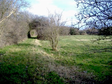 Longlands Road - The 1809 Enclosure Map shows the original Longlands Road ran from where Meadow Road changes direction at Lockwood Close to the south end
of the Rylands recreation ground. It then carries on in the same direction until it met the watercourse which is now the canal. The road then ran alongside what is now the northern bank of the canal
at the rear of the present sewage farm to where the Musco-Sike Drain runs into the canal. A remnant of this road is still visible on the northern side of the small paddock at the end of Cornwall Avenue (See left).
Longlands Road - The 1809 Enclosure Map shows the original Longlands Road ran from where Meadow Road changes direction at Lockwood Close to the south end
of the Rylands recreation ground. It then carries on in the same direction until it met the watercourse which is now the canal. The road then ran alongside what is now the northern bank of the canal
at the rear of the present sewage farm to where the Musco-Sike Drain runs into the canal. A remnant of this road is still visible on the northern side of the small paddock at the end of Cornwall Avenue (See left).