
|
The maps shown here and on the other two map pages, and the tables on this page, are the work of Geoffrey Drinkwater and
Stephen Wallwork and are included here with their kind permission. These maps and tables were originally connected with their work Early Roads and Footpaths in Beeston,
Nottinghamshire and Mapping Pre-enclosure Beeston which were first published in The Nottinghamshire Historian, Autumn/Winter 2002 (No. 69) and Spring/Summer 2007
(No. 78) editions respectively
The map shown below, identifies and locates the roads, tracks & watercourses mentioned in the Beeston Enclosure Award of 1809; the numbers shown
refer to information contained in the tables presented below the map. |
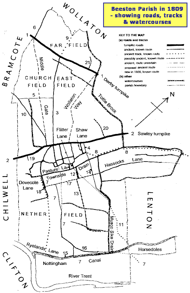
| Roads and Bridleways Mentioned in the Enclosure Award of 1809 |
No. on
Map | 1809 Name and designation; breadth | Present location. Comment. Age estimate. |
| 1 | Turnpike Road Nottinghan to Derby. In the course of the former turnpike; 50 ft. |
Derby Road. The former turnpike was probably on the ancient route referred to as Derby Strete in fourteenth century Middleton deeds. |
| 2 | Turnpike Road Nottingham to Sawley. In the course of the former turnpike; 40 ft. |
Beeston High Road and Broadgate. The former turnpike would, again, follow an ancient route.(The King's highway from Beeston to
Chilwell is referred to in 1637. |
| 3 | Cowgate Road. From Gravel Pit Lane to Derby Rd. To follow the course of the ancient Cowgate Road; 30 ft.; |
Wollaton Road, from the Commercial Inn to Derby Rd. This was the ancient route for cattle from the pasture to the East and West Fields
(separated by this lane). Before 1809, Wollaton Road from The Square as far as the present Cross Street was a village street called Gravel Pit Lane. |
| 4 | Pen Close Road. From the northeast end of the town of Beeston, to the east end of The City, of breadth 30 ft., into and over
Elizabeth Read's Pen Close, into Tuttle Brook Field, and northwest by the side of Pen Close to the Sawley turnpike; 40 ft. |
From a point about 40 yards west of the east end of The City, (at its junction with Shaw Lane. This would be the northeast corner of the
built-up area in 1809) along to its east end, of breadth 30 ft. There, entering Tuttle Brook Field and continuing left as Humber Road, of
breadth 40 ft., to its junction with Broadgate. Probably new in 1809. |
| 5 | Bridle Road from Beeston to Bramcote. From Cowgate Road, southwest over [three specified closes in] the Church Field to a Bridle
Gate into Bramcote parish; 10 ft. |
Bramcote Drive. No mention of an earlier course, and possibly only readily accessible from the extended Wollaton Road; therefore new in 1809. |
| 6 | Bridle Road from Beeston to Wollaton. From the Derby turnpike, along the Beeston/Bramcote boundary to Toadlands Lane; 15 ft.
Gate into Bramcote parish; 10 ft. |
The lower part of Sandy Lane, Toadlands Lane being the upper part. (Toadlands may be a corruption of Totelands - Tote referring to an ancient
Meeting place, cf. Tottle Brook). Probably an early route, only formally defined in 1809. |
| 7 | Bridle Road to Wilford and Occupation Road to Horse Doles Meadow. From Dovecote Lane, southeast over the Common Pasture, to and along
Flats Lane, then over Acrelands; Pasture, to and over the Trent Canal Bridge. Then northeast ver the Meadow by the side of the canal, into and over
plot 224 in the Nether Meadow, to the ancient enlosure called Horse Doles Meadow; 40 ft. Then southeast over 224 as a bridle road (10 ft.) by the
side of Horse Doles, to a bridle gate into Lenton. |
Dovecote Lane, from where it used to be crossed by the Townside Drain (now culverted) about in line with Leslie Avenue, to and along Queen's
Road, Station Road and Meadow Road, to and over the canal bridge, then left along the lane parallel with the canal as far as the present Lenton
boundary for about 95 yards to where the bridle gate used to be. (The Common Meadow lay on both sides of Queen's Road betwwen its junctions
with Dovecote Lane and Beacon Road. Acrelands Pasture was the area east of Meadow Road betwwen its junction with Longlands Road and the canal. The
site of Horse Doles Meadow is now in Lenton.) Most of this route is probably ancient, (see the possible link with the footway 11, below1),
though Longlands Road (no. 16 below) was probably a precursor of the section by the side of the canal, before the latter was built. |
| Public Footways Mentioned in the Enclosure Award of 1809 |
No. on
Map | 1809 Name and designation; breadth | Present location. Comment. Age estimate. |
| 8 | To Lenton and Nottingham. From the northeast end of the Town of Beeston, along [the first section of] Pen Close Road, continuing
in a nearly straight direction through [specified enclosure, along te continuation of the Town Side Drain, here called the West Hassocks Drain] and into
John Hodges' Hassock Close |
Starting as in 4, along The City, to its junction with Humber Road, crossing Humber Road and bearing right to join the east end of Fletcher
Road, then along the twitchell (which used to have the West Hassocks Drain alongside it) to the traffic island at the west end of University Boulevard.
Tough the designation finishes at about this point, the enclosure map shows the footway crossing to the south side of the watercourse which is
here joined by, and continues as, Tottle Brook, (now within University Park), roughly along the line of University Boulevard. |
| 9 | To Wollaton. From the Derby Turnpike, opposite the end of Cowgate Road, westward over the Far Field, to a turnstile leading to Wollaton. |
The path which now starts on Heather Rise and continues in the direction of Wollaton Road (i.e. northwards - 'westward' was clearly
an error), uphill to the area known as The Devil's Steps, where it enters Wollaton and descends steeply. Probably an ancient direct route
but too steep to be other than a footpath. |
| 10 | To Bramcote. From the Sawley Turnpike at or near a place called the Roundhill, westward over the Church Field and over [specified closes] to
a bridle gate [as in 5] into Bramcote. |
Along Foster Avenue and continuing as the twitchell which used to go diagonally across what is now the Roundhill School field but now skirts
its edge. The roughly along the line of the first section of Bramcote Road but continuing in a straight line to the bridle path which now crosses
the Beeston Fields golf course. Another direct route and so probably ancient. |
| 11 | To Wilford Ferry. From Musco Sike Bridge, across an adjacent close to a foot stile in the next close. |
From about the position of the traffic island at the east end of Lilac Grove, roughly diagonally across the Boots site. Though onlt specified
in the text of the enclosure award for about 100 yards, the map shows the track continuing to reach the Beeston/Lenton boundary just north
of the canal. This, and the existance before 1809 of the bridge over the Musco Sike Drain (see 14) suggest that this direct troute to the river
crossing is ancient. Before the canal was built, it may well have joined the last (10ft) section mentioned in 7, the bridle road to Wilford. |
| 12 | To Middle Pasture Road. From the east end of Flitters Lane, over a [specified] close, and into Middle Pasture Road. |
For Flitter(s) Lane, see the text. The path goes eastwards to join, and run along, the line of the common boundary between the line of the common
boundary between the gardens of the houses on King Street and Lower Regent Street. In 1809 that boundary was marked by the Middle Pasture Drain
which connected at its north end with the Townside Drain and the path ran along its southwest bank to Queens Road. The next path (13) appears
to be a continuation of this one. |
| 13 | Private footway to the vicar's allotment and Long Lands closes. From Middle Pasture Road and across [specified] allotments
in the pasture, the Thorndikes, and Longlands. For the use of the owners and occupiers of the vicar's allotment and closes crossed by or adjacent to the track. |
There is still a lane reprsenting the northwest end of this route (once known as Dirty Lane) between the backs of the properties on Windsor Street
and Mona Street. About where this lane ends at the railway was the vicar's allotment to the northeast. The track continued in the same direction
across the Thorndikes Drain (just south of Lilac Grove), and Longlands Drain, to Longlands Closes now occupied by the landfill site to the
north of the canal. This may have been originally an occupation road, serving the early enclosures in the Nether Field, or possibly an alternative
route to Wilford. |
Occupation Roads Mentioned in the Enclosure Award of 1809
(providing access to adjacent areas of land) |
No. on
Map | 1809 Name and designation; breadth | Present location. Comment. Age estimate. |
| 14 | Musco Sike Road. From the Pen Close Road [see 4, above]. southeastwards over the Tuttle Brook Field and the Common Pasture, to the Middle
Pasture Road (40ft); then continuing (33 ft breadth) in the same direction over the Pasture to Francis Evans' Musco Sike Close. |
Humber Road southeast of The City, the whole of Humber Road South, and following the line of The Padge railway bridge ('Boots Bridge')
and along the west bank of the Musco Sike Drain into what is now the waste disposal site adjacent to the sewage works. (The Musco Sike Drain ran
southwestwards from the Townside Drain at the east end of Fletcher Road. along the rear of the properties at the end of Myrtle Grove to join
the line of Beacon Road and Padge Bridge, and is now visible as it runs along the side of the sewage works towards the footbridge over the canal.)
This road probably dates from 1809. |
| 15 | Ryelands Road. From the canal bridge [at the end of Meadow Road] over the Acrelands Pasture, and along the northwest side of the canal
to Rylands Lane; 28 ft. |
The east part of Canal Side, the west part being the former Ryelands Lane. From the enclosure map, Ryelands Lane, probably constructed at the
same time as the canal in 1796, appears to be the section from the canal lock to a point a little to the west of the junction with Appleton Avenue.
A change in width about here supports the suggestion that the transition to the Ryelands Road of 1809 occurred at this point. |
| 16 | Longlands Road. From the Meadow Road, along the southeast ends of the Longlands Closes, and into and over the northwest sides of
[four specified] lands in the meadows, to Francis Evans' close; 20 ft. |
Not the present Longlands Road but leading eastwards from the bend in the present Meadow Road, at about its junction with Wood Close. Near the end
of Cornwall Avenue, it is visible as a track running just south of the Leyton Crescent Recreation Ground. From there it would have led to a point just to
the north of the footbridge over the canal neat the Boots site. The possibility of this being originally part of 7, as an ancient route to Wilford,
is mentioned in that section. |
| 17 | Middle Pasture Road. From the road previously awarded [in 7] northeast over the Common Pasture to the Hassock Lane; 40 ft. |
Queens Road between Station Road and Hassocks Lane. Since Hassock Lane is not defined in the award, it must have existed beforehand. Godfrey
suggests that these two roads, along with Long Lane in Attenborough, formed parts of an ancient track from a river crossing near Attenborough to Lenton. |
| 18 | Glead Wong Road. From the bridle and occupation road [7] southeastwards to John Fellows' Glead Wong Close (ancient enclosure); 30 ft. |
A short stretch of Dovecote Lane stretching from Queens Road to about Ireland Avenue. ('Glead' may be derived from the Old Norse word
gleda, meaning the bird called a kite, or from the Old English glaed, meaning a glade or open space in a forest. 'Wong' is an old term
for a meadow.) This old name and its association with Dovecote Lane, the bridle road [7] to Wiford, and with what may be an early route to the Trent,
suggest that this is an ancient section of road. |
| 19 | Road to Martins Croft. From the Sawley turnpike, over the northeast end of Open Hall Croft to and old inclosure called Martins Croft; 18 ft. |
The straight section of Hall Croft from Chilwell Road to where it begins to bear eastwards. (Open Hall Croft was a plot of land adjacent to Chilwell
Road between the present Hall Croft and the Chilwell boundary at Wilmot Lane. Martins Croft was a strip of land along the southeast border of Open
Hall Croft.) Perhaps the only new feature of this access road was its designated width. |
| 20 | Brook Close Road. From the Derby turnpike, into and over a new allotment and an ancient enclosure called Combs Close to the Combs Close
belonging to the Vicar of Beeston; 21 ft. |
Salthouse Lane but probably extended as far as Manton Crescent. This was probably an ancient access to old enclosures north of Broadgate, simply redesignated. |
| 21 | Combs Close Road. From the Sawley turnpike, northwestwards over the Tuttle Brook Field to John Wright's allotment; 24 ft. |
The eastern segment of Middleton Crescent, from Derby Road to about its highest point. (There were at least seven ancient Combs Closes stretching
along the Wollaton boundary defined by the Tottle Brook, between the Devil's Steps (see 9) and Wollaton Vale. A comb, now usually combe or coomb, from
the Old English cumb is a hollow or valley, often a hollow flank of a hill. This aptly describes the environment of these closes.) The road would
have been an old access road redefined. |
Click here to go back to the top of this page
|
|