| Home Topics Memorials Miscellany Transcripts References Family History Glossary Latest Beeston Blog About us | Site Search |
|
The Origins of the Placenames and Fieldnames of Beeston - by Ivan MorrellNatural Rood - Situated in the Far Field on the northern side of Derby Road in the area of David Grove and Magnolia Court. The name is believed to derive from O.E. Rod / Rodu meaning a natural clearing or woodland glade, this would make sense here being next to the woodland name of Derby Gate Hurst. Nether Field - One of the three Anglo-Saxon open fields of Beeston, Nether Field lay to the south of Beeston located between the Common Pasture that lay immediately to the south of the village and the Common Meadow that bordered onto the Trent. The Nether Field was enclosed early in about 1612, possibly a result of a population decline due to the Beeston plague of 1593/4 when arable land would have been turned over to meadow and pasturage and the less labour intensive rearing of animals.The name derives from O.E. Niðera and O.E. Feld meaning the lower field. Nether Street - As its name implies, Nether Street was the lower of Beeston’s streets deriving from O.E. Niðera and Stræt. Nurseries - The 1901 O.S. Map shows that there were nurseries once situated on the northern side of Derby Road as well as the area now covered by the Nurseryman public house. Nybbesdale - Documented in 1341, the dale name must locate this in the area of Derby Road or Woodside Road. The name may either have derived from a projecting point or beak of land, or an O.E. personal name like Nybba and O.E. Dalu. Oak Meer - This was another of the baulks and boundaries between groups of strips situated in the Far Field, running parallel with Sandy Lane from Derby Road to the Wollaton / Beeston parish boundary in the general area of the present Bourne Close. Named from the oaks that would have grown along the boundary, and deriving from O.E. Āc and Gemære. Oatesty - Known from a 1333 document, the Oatesty were probable located somewhere on the present Wollaton Road hillside. The name refers to an ascending pathway either to or through land where oats were grown. The name derives from O.E. Āte and either O.E. Stīg or O.Scand Stigr. Le Oldemor - Documented in 1341, le Oldemor can be identified as the later 1669 Old Morefield of Attenborough, Chilwell and Beeston. These moorlands are further identified from the 1845 Chilwell Tithe Map as the lands to the north and south of the present railway tracks, placing Le Oldemor in the area of the Rushy Closes, the Gleadwong and the present Beeston Station.The name derives from O.E. Eald and Mōr. Padge Cottages, Padge Bridge - Padge Bridge is the original name of Boots Bridge, named from the Padge Cottages that stood just on the Nottingham and Boots side of the bridge. Padge is a form of the name pudge, which is a Leicestershire term for the Barn Owl, giving a meaning:"the cottages frequented by the Padge or Barn Owl". Parson’s or Vicar’s Wong - Part of the land allocated to support the vicar and the parish church, situated in the Church Field in the general area of Glebe and Vicarage Streets. The name derives from Med. L. Persona and O.N. Vangr. Pasture Dyke - The Dike or Drain originated in Chilwell, flowing to the area of Leslie Avenue and Dovecote Lane in Beeston where it was known as the Heaning Drain. On crossing Dovecote Lane the dike changed its name to the Pasture Dyke or Townside Drain then flowed on via the present Westward Avenue and between Nether Street and Waldmar Grove to Humber Road and Fletcher Road. In the area of Fletcher Road the dike changed its name yet again to the West Hassock Drain running along the side of the Twitchell at the end of Fletcher Road to enter the Tottle Brook at the paddling pool end of Highfields. The name derived from L. Pastura and O.E. Dīc influenced by O.Scand Dyke. Pasture Lane - Pasture Lane also known as Asty Lane, ran from Nether Street in a southerly direction to the Pasture Dyke, between where the two main original buildings of the Nether Street School are now situated. The name derives from L. Pastura and O.E. Lanu. Penn Close Road - This was the old name for the northern section of Humber Road from the present High Road to The City. Penn Close was a part of Brook Furlong on the eastern side of this northern stretch of Humber Road. The name, because of its relative position to the village, probably refers to animal pens, deriving from O.E. Penn. Pinfold - The Pinfold, is believed to have been situated on the site of the old Beeston & District Urban Council offices, in the region of Foster Avenue, near to its junction with The Square. The Pinfold was a small enclosure where stray animals were kept by the Pinder until they were reclaimed by their owners upon the payment of a fine. The name derives from O.E. Pundfald. Plague Hole - This is said to be on the eastern side of the churchyard. It was here that the 137 victims of the 1593/94 plague were buried. The name derives from the LL. Plāga and O.E. Holh. Pollforth Yat Furlong - Listed on the 1601 Terrier, this may have been a name for the northern end of Far Field Drain, somewhere in the area of the present junction of Boundary Road with Brook Road. The name derives from O.E. Pōl, Forð, Geat and Furlang. Forth is a known Nottinghamshire dialect form for a ford, while Yat is a form of gate, giving a meaning of the passage through the ford in the pool. Pond Close - Part of the vicar’s glebe and situated near to the Old Vicarage at the western end of the present churchyard. Poor Row - Situated at the eastern end of the Churchyard, along Church Street near to the plague hole. Poor Row was a group of cottages built upon waste ground, where a few poor families resided in rent-free accommodation until the cottages were demolished in 1844/5. Purples Meadow, A Purple Piece, Half a Purple - This small close deriving from O.E. Purpl and Mædwe was situated on the north side of the canal in the region of the present Suffolk and Cornwall Avenues. The small paddock at the end of Cornwall Avenue maybe a remnant of this meadow. The name is a mystery, but it is thought that it was named from a plant which grew there, from the colour of its flower or foliage, or from a plant which yielded a purple dye. A probable contender is the common Prunella Vulgaris also known as Selfheal, a plant that grows locally and forms a purple carpet along dry grassy banks and grassland. A document of the 14th Century mentions a Purpilland lying overlonglands, a description accurately fitting the location of the Purples Meadow. A Purple Piece and Half a Purple refers to a part of one of the later ploughed strips of Purples Meadow. Pye Close - Part of the vicar’s glebe, this small close was situated to the north of Chilwell Road at the eastern end of the present Gladstone Street. The name means a close that was frequented by magpies, a previous name for the close may have been The Goares,[see above]. Robinett - Robinet Close mentioned in the 1586 will of John Bampton and in 17th and 18th Century documents, was situated in the area of Robinet Road. Robinett is a northern dialect name for the robin. Roger Lane, Roger Lane Heads - A possible inference from the itinerary of a 1601 Terrier is that Roger Lane may have been an older name for the trackway known as the Wollaton Way. The name may have derived from the family of Maud Rogers of Beeston, documented in the 14th Century, Heads, sometimes written as Hades, referred to a headland where the ploughteams turned, deriving from O.E. Heofodland. Rotten Brook - This is another name for the Tottle Brook in the area of Broadgate. The name has come informally from the "retting" [soaking] of Flax or Hemp in the brook which produced a stench. John Levis who held land in Beeston is described in various documents as a Nottingham grocer and flax dresser. Retting is a Middle English word of Germanic origin. Roundhill, Roundhill Garden - From an undated map [NUDMSC Ref No. Bn 148], it is possible to identify Roundhill as the area bounded by Foster Avenue, Nuart Road, Wollaton Street and The Square. The Roundhill, probably an old burial mound of pre-history, was, according to the map, located in the area of the Wollaton Road Methodist Church. In addition to this area, there is a plot shown on the 1809 Enclosure map that is called Roundhill, located at the eastern end of the churchyard where the Argos and Wilkinson’s stores now stand. Roundhill Garden was a small close in the general area of the Lloyds /TSB bank. Rufford - Situated in the Church Field and now part of Beeston Fields Golf Course. The name is a corruption of the earlier Rough Hough meaning the rough hillside, deriving from O.E. Rūh and O.Scand Haugr. Rushy Closes - These closes appear to have been part of the Old Moorfield of Attenborough, Chilwell and Beeston. They were situated on the Chilwell/Beeston parish boundary at the western end of the present Siemen’s site near to the railway line and Nature Reserve. The name which is self explanatory derives from O.E. Rysce. Rylands - The Rye Lands were situated on the northern side of the present canal to the west of Meadow Road incorporating the Acrelands and Flats Closes.The name which as been documented since at least 1323 and is probably far older, derived from O.E. Ryge and Land. Ryland names are common where the lands were not fertile enough for the better crops but were good enough for rye. Salthouse Lane - This lane named after the Salthouse family who held land there, was previously known as Brooke Close Road which led to John Wright’s allotment on the 1809 Enclosure Map.
Scallcroft / Skalcroft Furlong - It is thought that both of these two names from the same 1601 Terrier are representing different local pronounciations of the same name. In Nottinghamshire dialect there was probably a time when both of these pronounciations and spellings were current, depending on the speaker's or writer's Scandinavian or English background. From the itinerary on the terrier the names can be said to be earlier or alternative names for the enclosure in the Church Field known later as the Crawcroft. There are two possible origins for these names, firstly from O.E. Sceald, meaning a thin layer, shallow, perhaps referring to the depth of the soil or vegetation here. Secondly from O.Scand. Skali or a postulated O.E.form Scēla and O.E. Croft meaning an enclosure with a temporary hut or shelter. The need for a temporary hut or shelter on the top of the exposed Beeston Fields ridge a fair distance from the village would be all too apparent, especially if caught out there in bad weather. Of course, exposed sites such as this are often frequented by crows, which would have given rise to its later or alternative name of Crawcroft. Schortrylandes - This name from a 1341 document is thought to mean the short strips of land used for growing rye deriving from O.E. Scort, Ryge and Land, locating it somewhere within the Rylands of the Nether Field, see above. Sedcocke Furlong - From the itinerary of the 1601 terrier, the furlong may have been situated somewhere just to the north of Broadgate in the Tuttle Bridge Field. The furlong's name could have either have derived from the name of an owner, or be a corruption of Setecoppe also in the same vicinity. Setcop - The Setcops were closes in the Tuttle Bridge Field in the general area of Albion Street. The Setcop Furlong [see below] also occurred in the Church Field on the western side of Wollaton Road, telling us that the same seat-shaped topographical feature, from which the closes were named, stretched all across the hillside here. The name derives from M.E. Setecoppe. Setcott Furlong - This furlong, documented on a 1601 terrier, was probably an earlier name for the Gravel Pit Furlong in the Church Field. The name is probably a corruption of M.E. Settecoppe above. Shaw Lane - This lane which no longer exists ran from the High Road to The City, running parallel to and between Regent Street and Humber Road. The name derived from the Shaw family who held land in Beeston throughout the 16th, 17th and 18th Centuries. Shawcroft mentioned on several Drury documents of the 18th Century would have been situated along Shaw Lane. Sheppards Close - Documented in the 1818 will of Thos. Charlton, the name probably derives from the family of Joseph Sheppard who held land in Beeston in the 18th and 19th Centuries, location unknown. Long and Short Shinbones - Located in the Far Field in the area of the present Anderson Cresent, Dennis Avenue and their junctions with Central Avenue. The name normally occurs in fieldnames describing the field’s long narrow shape which seems unlikely in this instance, so the name here probably arose referring to the field’s strips being originally much narrower than was normal. The name that was known in 1341 as le Schynbandes, derives from O.E. Lang, Scort and Scinbān. Short Furlong - Located in the Church Field in the area between the present Newton Street and Silverwood Road. The name, deriving from O.E. Scort and Furlang, is self explanatory. Silverlands and Silver Hill - Documented on the 1601 Terrier as the Sylver Lands, they were part of the Tuttle Bridge Field. The Silverlands were the southern part of the present Woodside Road, from Broadgate on the north to Lower Road on the south. Silver Hill was the easternmost section of Broadgate where it slopes down to meet Woodside Road. The name is said to have come from the Silver Birches which grew upon this hillside, deriving from O.E. Seolfer and Land. Nether and Over Smallthorn - Located in the Church Field between the present central part of Bramcote Drive on the north, and Park Street on the south. Documented in 1333 as Le Smale thornes. The names derive from O.E. Niðera, Ofer, Smæl and ðorn, O.E. Smæl at this time had the meaning of thin, slender or narrow and only came to mean small in the modern sense some time later. There are two possible origins here, that the lands possibly called "The Thorns" had narrower than usual strips or selions, or that the thorns were slender indicating that the hedges were planted with cuttings of Hawthorn known later as Quickset or Quickthorn. The name possibly indicates an early enclosure in the open field system. Stayfurlong - Mentioned in two 1323 documents, its location is unknown. The name may have derived from O.E. Stæf and Furlang meaning the furlong marked by a staff or post. Middle, Nether and Over Steeper - The Steeper closes were situated on the northern side of Derby Road, to the east and west of an old footway that ran northwards from directly opposite Wollaton Road. The old footway ran from Derby Road by the Steeper Closes uphill to an area that was known as the "Devil’s Steps" where it entered Wollaton and descended steeply. The name Steeper or Steopoe, and documented in 1341 as Stepowe, derives from O.E. Stēap and Hōh, meaning a steep heel or projecting hillspur of land Stonehouse Hay Sike Close - Stonehouse Hay Sike Close is mentioned in several 18th Century documents. The name of Hay Sick Close in these cases is a corruption of Hassock Close. The fieldnames of Stonehouse Meadow and Stonehouse Wong are known from that part of Lenton Parish that butts up to the Beeston boundary between the Tottle Brook and Beeston Lane. Some of this Lenton land situated in the area between the present Paddling Pool and the University's western entrance on Beeston Lane, and held in the 18th and 19th Centuries by the Drury and Lowe families, was for a time credited to be part of the Parish of Beeston.The name derives from O.E. Stān, Hūs and Hassuc. Stoneyland - Located in the Church Field in the present area of Silverwood Road and Ireton Street, and known as Le Stoniland on 14th Century documents. The area stands on an old gravel terrace, so is self explanatory. It derives from O.E. Stān and Land. Stoney Land Closes - Located in the Tuttle Bridge Field in the area of the southern end of Manton Cresent and Arden Close. The name again is self explanatory, since the close lies on a gravel terrace. Strawcroft - This homestead or enclosure was situated in the Church Field probably within the confines of the village, but the precise location is unknown. According to Robert Mellors 1916 book "Beeston Then and Now" the name of the Strey family who held Beeston Manor was pronounced locally as Strawe. It is probable then that the Streys owned this croft, as no Nottinghamshire family name of Straw has been documented in Beeston. Street Furlong - The furlong was located in the Church Field in the area of the present Imperial Avenue. The location of the furlong was nowhere near to a main thoroughfare, so the name probably derived from a person with the surname of Street rather than being named from its position relative to a highway.The name may refer to the families of Allice Streetes or Ann Street, married in Beeston in 1593 and 1735 respectively, or of Joan Strete married at Attenborough in 1560. The surname is also known from the 1945 Chilwell Tithe Award, where a John Street was listed among the trustees of Clar's Lane Methodist Chapel. The name in both of its possible senses derives from O.E. Stræt and Furlang. Swan’s Field - This late fieldname from the 1863 Middleton Estate Map was situated in the area of the present Cyprus Avenue, and originated out of the enclosure of Cowgate in the Tuttle Bridge Field. The field was named after the family of Christopher Swann who lived in Clansey Cottage on this site in the mid 19th Century. Thorndyke Drain and Closes - Thorndyke Drain ran from the area of the junction of Meadow Road and Lilac Grove, across Lilac Grove to the site of the Recycling Centre. All the lands which were to the south of this drain, bounded by Meadow Road on the west, Longlands Drain on the south, and Musco-Syke Drain on the east, were known as the Thorndyke Closes, probably arising from the enclosure of most of the Nether Field in 1610. Documented in the 14th Century as Thorndic, the name derives from O.E. Þorn and O.E. Dic. Toadlands Lane, Toadlands and Toadlands Close - Toadlands Lane was an earlier name for Sandy Lane. The Toadlands which were situated on the eastern side and central section of this lane were known as the Fold Lands on the later 1863 Middleton Estate Map. According to an 1834 Indenture, Toadlands Close which was part of an old enclosure of the Toadlands, was by that time known by the name of Intake, [see above]. The name Toadlands derives from O.E. Tade and Land, and the alternative name of Intake tell us that the Toadlands were once considered as moorland. Tottle Brook - The Tottle Brook rises on Trowell Moor near to the aptly named Spring Farm, flowing on to form the Beeston/Wollaton boundary between the present southern halves of Wollaton Vale and Appledore Avenue. The brook crossed Derby Road at the Tuttle Bridge just to the west of Priory Island and formed the Beeston/Lenton boundary roughly down the route of Woodside Road, before flowing on through Highfields. The brook now runs just to the north of University Boulevard crossing the boulevard near to the present Putting Greens and on through Dunkirk. From Dunkirk the brook then ran alongside the old Chain Lane and Trent Lane [now Lenton Lane] before it looped round to enter the Trent near to the site of the old Wilford Power Station outflow opposite Wilford Church. There is mention of a Tuttle Berry Gate in a 1575 bounds of Lenton, from the other names mentioned in these bounds Tuttle Berry Gate can be identified as an earlier name for Cut-through Lane. Both the forms Tottle and Tuttle take their names from O.E. Tote and Hyll, meaning lookout hill. The hill in question is thought to be the hillside at Strelley which includes Catstone Hill, it is from below this hill that the Tottle Brook rises near to the aptly named Spring Farm. The hillside was part of the militarized system set up by Anglo-Saxon Kings of Wessex in the 10th century for the defence of the shire against Viking attack. Towlson/Towson Lane - This small lane which no longer exists, and is known on the later 1881 O.S Map as Wood Street, ran between Middle Street and Nether Street directly opposite Acacia Walk. Called Towson Lane on the 1841 Census and Towlson Lane on the 1851 Census, the lane took its name from the Towlson family who were recorded living on the lane in 1841 and 1851. The Nottinghamshire name of Towlson derives from the O.Scand personal name Toli and O.E. sunu. Trent Close - Trent Close, as its name indicates, butted onto the Trent and was located in the Nether Field in the area of the present Beeston Marina, incorporating the western ends of Riverside Road and Trent Vale Road. The name Trent derives from the Old British Trisanton which is believed to mean the trespasser, i.e. liable to flooding. Turnip Hay Sike Close - This close was mentioned in the same Drury documents as Stonehouse Hay Sike Close. Hay Sick Close, in both of these cases, was an 18th Century corruption of Hassock Close. Turnip Hassock Close may well be another instance of Lenton lands that were once credited to the Parish of Beeston. The name derives from O.E Nćp + later turn denoting its round shape, and O.E. Hassuc.
The Old Vicarage - The Old Vicarage which was demolished in 1860 stood on the south-western side of the church, on the site of the present doctors' surgery. It was described on a 1704 Terrier as being built of mud, stud and thatch, by 1809 however it had been somewhat improved, being built then of bricks and mortar. Union Street - Union Street first constructed in the first quarter of the 19th Century. It was believed by the local historian Arthur Cossons to have been named from the Act of Union of the Irish and English Parliaments that occurred on 1st January 1801. Other local historians however, believe it may commemorate Beeston becoming part of the Basford Poor Law Union as a result of the Poor Law Amendment Act of 1834. Vicar’s Gowt - This name, documented in 1777, may refer to one of the fields on the banks of the Trent in the Common Meadow. There are a number of possible explanations for the origin of this name. The name could be a local colloquilism for the meadow allocated to the vicar for tithes on the 1809 Enclosure Map, or be a corruption of O.E.Gotu, a channel, which has dialectual forms, gote, goit and goyt. There is an old cut or channel of the Trent here which could have given rise to the name, running from near the present island in the river diagonally across this meadow in a westerly direction towards Beeston Lock. Alternatively, it has been suggested, that the name could have developed from O.E.Geotan, meaning to gush, referring to the shallows in the river here, forcing it to flow much more quickly through one narrower, deeper channel. Villa Street - In existence prior to 1841 and probably named from the houses of the lace manufacturers that stood near to the top of Villa Street, or from the residence that was known in 1851 as "The Villa" that stood on Turnpike Road [High Road] near the corner of Union Street. The 1851 Census records a John Watson living at "The Villa" who was a partner in the firm of F.B.Gill & Co. that ran the Silk Mill in Beeston. Nether and Over Waterslake - These two closes were situated in the Far Field, on the southern side of Derby Road from the present Burrows Cresent to Wollaton Road. Over Waterslake, which occupied the western part, was later known in the mid 19th Century as Barkers Field, named from the family of George Barker. The name Waterslake also occurs in the Church Field in some documents, so the name at some period must have applied to the whole of the valley on the southern side of Derby Road. Waterslake derives from O.E. Wćter and O.Scan. Slakki meaning a wet shallow valley. Wedcroft - This was a small enclosure situated on the southern side of the West End. The name derives from O.E. Weod and Croft, meaning the weed covered enclosure. Well Furlong - Situated in the Church or West Field, in the area that is now part of Beeston Fields Golf Course to the north of Bramcote Drive West. The field’s name which derives from O.E. Wiell, took its name from the spring or stream known as the Church Field Drain. le Westdole - This name which is known from a single reference on a document of the 14th Century is unidentifiable. Meaning the western part, share or strip, le Westdole could in theory have been part of any field within the parish, deriving from O.E. West and Dal. Westend - The name is self evident, situated at the western end of Beeston village. le Westhall - Documented in1333 this is probably an earlier name for either Bramcote Nook or Black Mould Nook, describing the western corner or nook. Like le Esthalle the name derives from O.E. West and Halh corner of land, rather than O.E. Heall, hall. West Furrows - Located in the Far Field they were probably a part of the Broom Closes in the area of the present Rydal and Kendal Drives. The name derives from O.E. West and Furh. Wheatlands - The Wheatlands were located in the Nether Field to the south of the Gleadwong which correspond to the present Siemens site. The name derives from O.E. Hwćte and Land, other forms of the name, Watelands, Wetelands, and Wyetelands, are recorded on other 14th Century documents. Whetstones - Situated in the Far field and named from a place where sharpening stones were obtained. The precise location is unknown, but it is thought to have been somewhere near to the Beeston/Wollaton parish boundary to the north of Derby Road. The name derives from O.E. Hwete and Stan. Long and Short Whitebutt - These two closes, situated in the Far Field, formed the corner of the present Woodside Road and the beginning of Derby Road on the Beeston/Lenton boundary. The names derive from O.E. Lang, Scort, Hwīt, and Bytt. Where the name white occurs in fieldnames it often refers to infertile soil, butt meant strips or a small amount of land abutting onto a boundary. Whitemans or Wheetmans Row - Situated in the Far Field in the area of the southern end of Appledore Avenue. The name Whiteman probably referred to a past owner who held this group of strips. Row derives from either O.E. Rćw or Raw. Wolfwong - Documented in the 14th Century, actual whereabouts unknown. The name probably derives from the Old Scandinavian personal name of Ulf and O.Scand Vangr meaning Ulf’s meadow. Wollaton Gate / Way - This lane, called Wollaton Gate on 17th Century documents and Wollaton Way in 18th century conveyances, ran from the present Derby Street / High Road junction to the point where the Tottle Brook crossed Derby Road at the Priory Island. An earlier name for the lane may have been Roger Lane. The name probably derives from O.E. Wulflafestun, O.Scand Gata and O.E. Weg. Wranglands - Listed on the 1601 Terrier in the Church Field, Wrang in fieldnames normally has the meaning of the crooked land. It can therefore be identical in meaning to the Crookroods which are also mentioned on the same 1601 document. In Old English however, Wrang also had the meaning of rough or uneven, so it seems probable that, in this case, the Wranglands could have been an earlier or alternative name for the Rufford Furlong in the Church Field. The name derives from either O.Scand Vrangr or O.E. Wrang and O.E. Land. Wright’s Croft - The name is known from the 1851 Beeston Census aa an adjacent entry after "The Villa" on Turnpike Road. The croft can be identified from the 1881 and 1901 O.S. Maps as the piece of open ground directly opposite Villa Street just to the east of Acacia Walk on the High Road. The croft would have been named from the family of John Wright. or - Click here to go back to the top |
|
||||||||||||||
|
|
||||||||||||||||
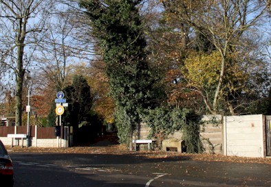
 Sandy Lane - This lane (Seen right) formed the boundary between Bramcote and Beeston to the north of Derby Road. Sandpits and sand extraction that
have been documented in Beeston are the origins of the name deriving from O.E. Sand and Lanu.
Sandy Lane - This lane (Seen right) formed the boundary between Bramcote and Beeston to the north of Derby Road. Sandpits and sand extraction that
have been documented in Beeston are the origins of the name deriving from O.E. Sand and Lanu.
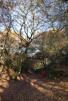
 The Twitchell - The Twitchell that now skirts round the edge of Roundhill School originally ran from the end of Foster Avenue, diagonally
across the school field in a north westerly direction to Bramcote. (A surviving part of this old track to Bramcote, seen from the top of Bramcote Road, is shown left)
Twitchell initially derived from O.E. Twicene meaning a forked way, describing the division of
the old trackways here that formed the routes to Bramcote and to Wollaton via Sandy Lane. The name later developed a meaning of a passageway between two walls or hedges,
M.E. Twitchell. It is this later Middle English meaning that applies to the Twitchell at the end of Fletcher Road, being a hedged passageway with no division of the pathway.
The Twitchell - The Twitchell that now skirts round the edge of Roundhill School originally ran from the end of Foster Avenue, diagonally
across the school field in a north westerly direction to Bramcote. (A surviving part of this old track to Bramcote, seen from the top of Bramcote Road, is shown left)
Twitchell initially derived from O.E. Twicene meaning a forked way, describing the division of
the old trackways here that formed the routes to Bramcote and to Wollaton via Sandy Lane. The name later developed a meaning of a passageway between two walls or hedges,
M.E. Twitchell. It is this later Middle English meaning that applies to the Twitchell at the end of Fletcher Road, being a hedged passageway with no division of the pathway.